
Trip to Green

What is Trip to Green?
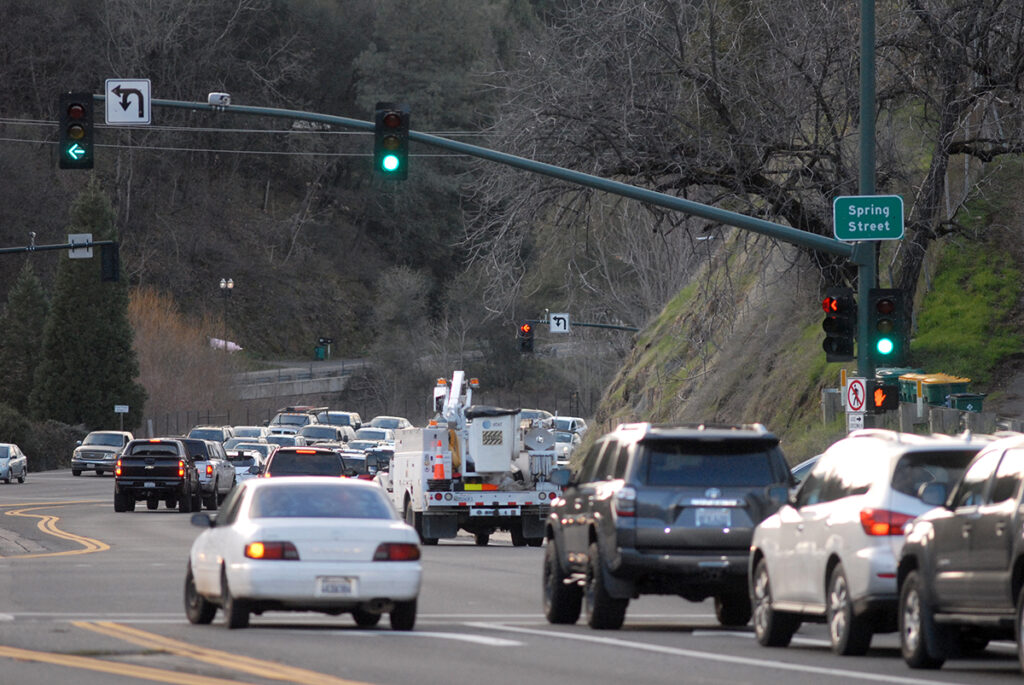
For three weekends in the summer and fall of 2022, traffic signals on both eastbound and westbound US 50 in the City of Placerville were set to stay green so that traffic could flow freely. To ensure safe travel, northbound and southbound movements across US 50 at Canal Street, Spring Street (SR/Highway49), and Bedford Avenue were closed to public traffic, allowing emergency vehicle access only. Right-in and right-out access remained available at Spring Street, Center Street, and Bedford Avenue. Detours were available and information was provided below for local traffic wishing to travel outside of US 50.
Planning Activities
EDCTC and the project team recently completed the US 50 Corridor System User Analysis, Investment Strategy, and Access Control Action Plan. The Plan was presented to the Commission on May 4, 2023 and was accepted as complete. Please see Plan link below:
US 50 Corridor System User Anaylsis, Investment Strategy, and Access Control Action Plan.pdf
Additional information from the public outreach workshops that took place is available below:
December 2022
(no presentation at the workshop)
December 2022 Workshop Summary
January 2023
February 2023
View Video Here
After the final of three Trip to Green Pilots were completed in October of 2022, a public survey was made available beginning October 17 through November 7. The results of the survey are included in the Engagement Summary for the Trip to Green Pilot project, which is posted below:
Dates of Closures
Traffic signal closures took place three weekends during the fall of 2022:
- August 6 & 7: from 8am - 8pm each day
- September 3, 4 & 5: from 8am - to 8pm each day
- October 1 & 2: from 8am - 8pm each day
Detour Maps and Routes
Signage will be placed along each detour route.
US 50 CORRIDOR ACTION PLAN INTERACTIVE DETOUR MAP.
CLICK HERE
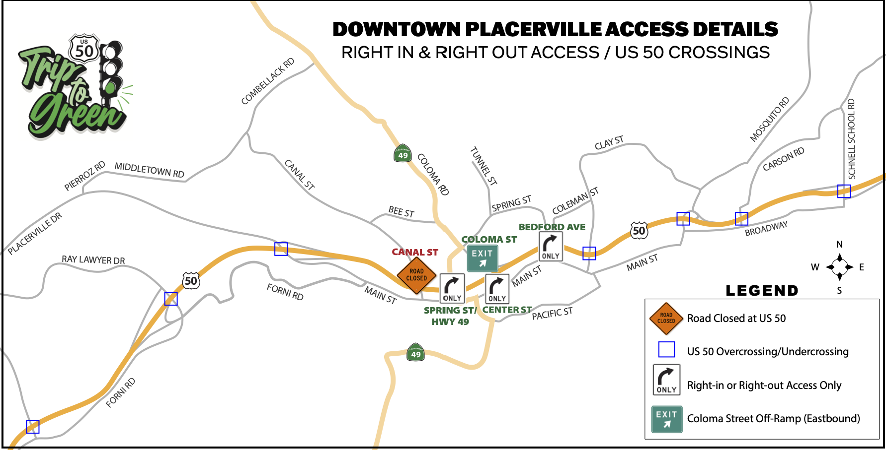
Right-in/Right-out Access and US 50 Crossings
During the closures, right-in and right-out access will remain available at:

Spring Street: Travelers will have the ability to turn right on Spring Street from US 50 in both the eastbound and westbound directions. They will also be able to turn right onto US 50 from Spring Street. Only emergency vehicles will have access in the north and southbound directions as needed.
Center Street: Travelers will have right-in and right-out access to and from Center Street on Eastbound US 50. The Coloma Street westbound off-ramp to Spring Street/SR 49 will remain open
Bedford Avenue: Travelers will have the ability to turn right on Bedford Avenue from US 50 in both the eastbound and westbound directions. They will also be able to turn right onto Eastbound US 50 from Bedford Avenue. Only emergency vehicles will have access in the north and southbound directions as needed.
Canal Street: Access in the north and southbound directions across US 50 will be prohibited for the duration of Trip the Green Light.

US 50 crossings will be available at: Placerville Drive | Ray Lawyer Drive | Clay Street | Carson Road | Mosquito Road | Schnell School Road
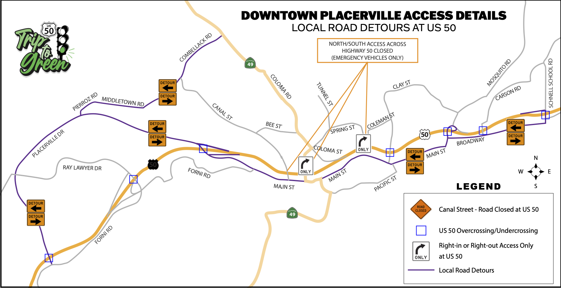
Local Road Detours at US 50
Detours around US 50 were in place for Main Street, Broadway, and Placerville Drive. Travelers used these roads to travel east and west and traverse north/south at the following available crossings:
US 50 crossings were available at: Placerville Drive | Ray Lawyer Drive | Clay Street | Carson Road | Mosquito Road | Schnell School Road
For travelers in Placerville who wished to access US 50, directional access was available as follows:

Eastbound: Forni Road at Lo Hi Way, Ray Lawyer Drive, Spring Street/Hwy 49 (from south side, right in), Center Street (from south side, right in), Bedford Avenue (from south side right in), Schnell School Road

Westbound: Placerville Drive near Forni Road, Ray Lawyer Drive, Spring Street/Hwy 49 (from north side, right in), Bedford Avenue (from north side, right in), Mosquito Road, Schnell School Road
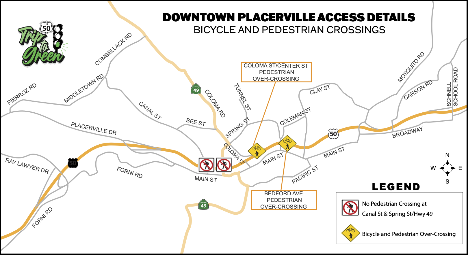
Bicycle and Pedestrian Detours
During the Trip to Green weekends, Pedestrian/Bicycle Crossings were detoured from their current at-grade highway locations at Canal Street and Spring Street for safety. Alternative access was provided at the existing pedestrian/bicycle overcrossings located at Coloma Street/Center Street (adjacent to El Dorado Trail). Please see the map below for locations.

Pedestrian/Bicycle Detour from Canal Street
To access the nearest overcrossing from the closures at Canal and Spring Streets from the south side of US 50, travel west on Main Street and turn left on Center Street to access the Center Street overcrossing.
To access the nearest overcrossing from Canal Street on the north side of US 50, take Bee Street to Coloma Street/SR 49, turn right and continue down Coloma Street to the overcrossing.
Pedestrian/Bicycle Detour from Spring Street/Highway 49
To access the nearest overcrossing from Spring Street at SR 49, take Coloma Street to the overcrossing at US 50.
Pedestrian/Bicycle Detour to Bedford Avenue Overcrossing
To access the nearest overcrossing from the closure at Bedford Avenue from the south side of US 50, travel west on Main Street and turn left on Bedford Avenue to access the Bedford Avenue overcrossing.
To access the nearest overcrossing from Bedford Avenue on the north side of US 50, travel south on Bedford Avenue to access the Bedford Avenue overcrossing.
Why Trip to Green?
Today, US 50 sees nearly 50,000 vehicles per day, and on peak/holiday weekends, it is even higher than that. Agritourism, outdoor recreation and general awareness of the areas in and surrounding our community have evolved to year-round activities, and vacation travel to Lake Tahoe, what once was a seasonal expectation of congestion, has become a year-round impact.
When traffic backs up, it spills on to local roads that serve as parallel facilities, such as Broadway, Main Street, Airport Road, Pacific Street, and other local roads, which makes it even harder for locals to get around. Businesses are also finding that travelers are not stopping once they get to town because of the travel delays they are already experiencing to get through the intersections.
Permanent improvements take time to plan, design, fund, and ultimately construct. Until long-term solutions are identified, funded, designed, and constructed EDCTC, the City of Placerville, and Caltrans are looking to test near-term lower cost solutions to relieve congestion, and improve the transportation network in and around Placerville. The project is intended to be a low-cost simulation of whether and how potential infrastructure improvements could improve traffic flow through Placerville.
Frequently Asked Questions
Click here to see a list of frequently asked questions for the Trip to Green Project.
Questions and Comments
For questions about Trip to Green, please contact EDCTC here.
Project Partners
.png?ixlib=rb-1.1.0&w=2000&h=2000&fit=max&or=0&s=c167cb6ae47b3058bdd63dfb12fc6bc7)